Maps
19-1. Benghazi’s Ancient Past.
Two maps of Libya, both specifically including Benghazi, using its historical name Berenice: “Libya Deserta et Cyrenaica,” c. 1750, 6¼ x 8½, copperplate. Hand-tinted in blue and green.
Including Cyrenaica and “Syrtis Maior” (Gulf of Sidra), on which Benghazi is today the largest
city. Trimmed at right, the whole mounted, ruled frame extended by hand, and first two words
of title curiously hand-lettered and inlaid, judged done c. 1900; stain on one letter of title, else
about very good. • “African Antiqua,” with inset of Libya, including Berenice (Benghazi) and
Tripolitana, another thorn in America’s side from the early Federal period. Published by R.
Wilkinson, London, Dec. 1, 1798, 10½ x 13¼, old watercolors in yellow, greens, and pink.
Showing North Africa, Gibraltar, the Spanish coast (seeing massive influx in today’s news),
the Balearic Islands, Sardinia, and Mauritania, Numidia (vanquished by Vandals, 428 A.D.),
and “Africa” - interestingly applied here specifically to modern-day Algeria and Tunisia,
including Carthage. Two tears at upper left corner, else fine. Fascinating context for modern
geopolitics. $90-120 (2 pcs.)
“Libya Deserta et Cyrenaica,” c. 1750, 6¼ x 8½, copperplate. Hand-tinted in blue and green.
Including Cyrenaica and “Syrtis Maior” (Gulf of Sidra), on which Benghazi is today the largest
city. Trimmed at right, the whole mounted, ruled frame extended by hand, and first two words
of title curiously hand-lettered and inlaid, judged done c. 1900; stain on one letter of title, else
about very good. • “African Antiqua,” with inset of Libya, including Berenice (Benghazi) and
Tripolitana, another thorn in America’s side from the early Federal period. Published by R.
Wilkinson, London, Dec. 1, 1798, 10½ x 13¼, old watercolors in yellow, greens, and pink.
Showing North Africa, Gibraltar, the Spanish coast (seeing massive influx in today’s news),
the Balearic Islands, Sardinia, and Mauritania, Numidia (vanquished by Vandals, 428 A.D.),
and “Africa” - interestingly applied here specifically to modern-day Algeria and Tunisia,
including Carthage. Two tears at upper left corner, else fine. Fascinating context for modern
geopolitics. $90-120 (2 pcs.)
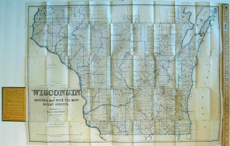
19-2. An Antebellum Pocket Map of Wisconsin.
“Chapman’s Sectional Map of Wisconsin, With the
most recent Surveys,” published by S(ilas)
Chapman, Milwaukee. 1853. Lithographed by F.
Mayer & Co., 96 Fulton St., N.Y. Evidently
unrecorded variant, with county boundaries
hand-tinted in blue, rather than red. Opening to
21 x 30, folding into its original case, 3½ x 5½,
forest-green embossed buckram over boards, with
original label. Apricot paper lining offers other
“valuable maps” of Wisconsin; at least the lining printed by Murison & Kerr, Milwaukee. Some
occasional spots of foxing, few short fold tears, minor wear at some fold junctions and blank
edges, light uniform toning, else very good, in fine case. Pocket maps are now moderately
elusive. $650-900
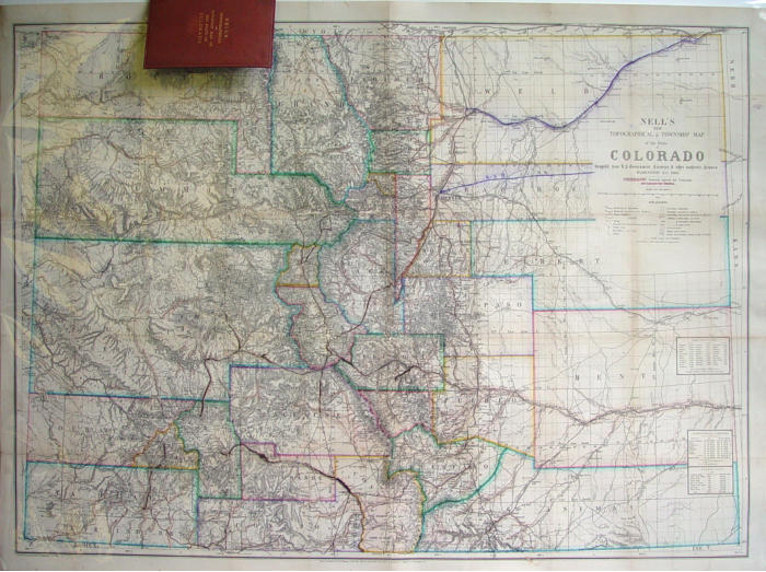
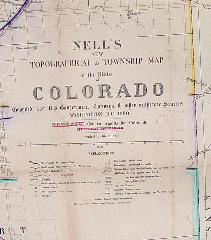
19-3. The Most Complete Colorado Map of the Period.
The very rare first edition of Louis Nell’s hand-
colored pocket map of Colorado, 1880, opening to
about 27 x 38. “Nell’s New Topographical &
Township Map of the State of Colorado, Compiled
from U.S. Government Surveys & other authentic
Sources....” Counties and rivers outlined in nine
colors. “Stone & Co., General Agents for Colorado,
372 Larimer St., Denver,” apparently shown
thusly on this edition only, crossed out in pink,
with handstamp of “Chain & Hardy, Booksellers &
Stationers...Denver” beside. A superbly detailed
map - likely the most complete post-Statehood
map of Colorado - exhaustively detailing its
geography and topography, including mountain
elevations, trails, wagon roads and railroads -
both existing and proposed, post offices, military
reservations, private grants, astronomical positions, arable land, and a wealth of other
details. Mapmaker Nell worked on the 1871-1879 Wheeler Surveys, and used his gleanings
to produce what is here regarded as the best large-format map of Colorado of its era,
becoming a commercial success. Long ago removed from its pocket map case (present!),
and in an intriguing and possibly related use, a Western traveler of the period has neatly
traced, first with purple watercolor, then brown fountain pen, his journey by river and rail
through central Colorado, the erosion in places of his iron gall ink adding to map’s patina
and interest. He has added a new route of the “C.Y.Q.[?] R.R.” coming from the east,
passing through Living Spring, Colo., terminating in Denver. Acquired rolled by consignor,
apparently separated at central vertical fold, inconspicuous loss of live matter totalling 2”
along one fold, minor wear and some light toning along some others, now professionally
conserved, backed with a very fine archival tissue, laid loosely on foamcore board for
display, and fine, clean, and a wonderful conversation piece. • With its pocket case, gilt on dark mocha embossed cloth over boards.
Publisher’s advertisement on pistachio inside front lining, also offering “Morrison’s Mining Rights” and “Jackson’s Photographs of the
West.” Lacking back lining, where map was removed for display and annotation by its 19th-century editor. Rumsey 662 (1883 edition).
(Credit for some descriptive text above: raremaps.com.) Another example, folding in case, sold for $5,200 in 2007 at Dorothy Sloan’s
auction. $2500-3500
19-4. Old New York.
Pocket map, “Disturnell’s New Township Map of the State of New-York, showing all the Canals, Railroads &c.,” 1850. Attractively
blind-tooled buckram, variant brown, gilt title. 1850 pencil inscription. By J. Calvin Smith. Pub. by J. Disturnell, 157 Broadway, N.Y.
19½ x 25. Steel-engraved on thick onion skin, with lovely original colors in pistachio, apple green, buttercup yellow, pink, and
strawberry. Exquisite insets of street plan of “City of N.Y. with part of Brooklyn and Williamsburgh,” with near-miniature detail, and of
“St. Lawrence River, from N.Y.S. Line to Quebec.” Complete states of Conn. and Vermont, and much of Mass. and N.H. Very old white
paper tape repairs on verso, near rear board; some expected breaks at fold junctions, soft creases from air pockets when folded, front
board separated, else very good and quite appealing. Noted ex-lib handstamp, 1877. WorldCat locates only one institutional example, at
SUNY Geneseo. Excessively rare. $275-350
19-5. Folding “Map of Boston.”
Metropolis Map Co., (1890). Jade green wrappers. Opening to 14 x 17. Red, navy, and black. With directory of buildings. Front cover
separated, corner of both covers lacking from water damage, map miraculously unaffected, some internal breaks at fold junctions, else
clean and very fine. Noted ex-lib handstamp, 1935. WorldCat locates five examples. $55-75
19-6. Pocket Map of Connecticut, 1890.
“Pocket Map and Shippers’ Guide of Connecticut...showing in detail the Entire Railroad System...and Accurately Locating all Cities,
Towns, Post Offices, Railroad Stations....” Rand, McNally & Co., 1890. Brown card covers, 4 x 6½. Comprising 30 pp. alphabetical
listing of businesses, towns with populations (Coventry pop. 25, Glenbrook 112, Hartford 53,230, Trumbull 118, West Norwalk 30), and
other Connecticut place names. An astonishing roster of 30 different railroads operating within the state. Cover with light water
staining, corner and handling wear; text staples pulled from cover, browned, some edge chipping, else good plus. • Map tipped to inside
rear cover, opening to 14 x 20¾, green, pink, yellow, and orange. Light toning on blank verso panels facing text, else seldom opened.
Important ex-lib handstamps, 1925. A charming item. Even as it gained importance in the late Industrial Revolution – the Connecticut
River Valley boasted some of the world’s most advanced industry in machine tools and brass works – the state was still remarkably
underpopulated. $60-80
19-7. Pocket Map of Campobello Island.
Folding “Plan of Campbello Island, New Brunswick...,” 1887, later made famous as F.D.R.’s vacation spot. In evergreen linen over
boards, gold-stamped title, 3½ x 6¼. Peacock-feather motif on caramel endpapers. Opening to 11½ x 18¾. Typographically
ornamental title. “Redrawn by J.E.H. 1887 [from 1883 map by Louis DeW. Washburn] / Heliotype Printing Co., Boston.” Some road
highlighting in blue pencil. Internal short breaks at three fold junctions, pinhole at two others, uniform cream toning, else excellent;
cover with light corner wear, else very good. Noted ex-lib handstamp, 1947. Rare. WorldCat locates only five examples. $110-140
19-8. Town of Prohibition, population 12.
“Cram’s Indexed County Map and Shipper’s Guide of Louisiana ...showing in detail the Complete Railroad System and the Express
Company Doing business over each Road....” C. 1890. 4 x 6½, in apricot wrappers, comprising 54 pp. Guide, and folding map tipped at
rear. Dozens of railroads serving the state, including Big Creek, Bon Ami & Red Buck Line, Louisiana Nickel Plate, Natchez, Urania &
Ruston, and many others; list of steamship lines and packet companies. A profusion of tiny towns, with nearest railroad station noted
for each, including Almadane pop. 18, Baskin 29, Baton Rouge 11,506, Cecil 25, Empire 23, Holland 5, Newlight 12, Prohibition 12,
Sugarcreek 15, and many others; some are apparently so small that the population is unrecorded. Covers with marginal waterstains,
adhesions on several letters; text with colorless light marginal water evidence, else good plus. • Map tipped to inside rear cover,
opening to 17¾ x 25. Charmingly colored, counties outlined in lemon yellow, nearly 100 railroads denoted with complex key of dotted
and dashed lines in sky blue, green, red, and royal blue. Short internal breaks at several fold junctions, breaks at several edge folds in
blank margins, very light toning, else V.G. Noted ex-lib handstamp, 1948. $70-100
19-9. “Political Map of the United States, 1877.”
Pocket map, published by James L. Onderdonk, N.Y., 3¾ x 6, in blind-tooled brown cloth, copper-stamped title. List of Senators of
45th Congress on front endpaper. Opening to about 22½ x 28. “Ed. W. Welcke & Bro., Photo-Lithographers...N.Y.” Shaded in green,
pink, and black, the entire country depicted by party and politician. Boxes showing “Party & maj(ority)” of N.Y.C., Philadelphia,
Brooklyn, Boston, St. Louis, Baltimore, Cincinnati, and Essex & Hudson Counties (N.J.), powerhouses of the day. Cover nearly
separated at spine; about half of map separated at its folds, variously by single, double, or group of six panels, requiring reassembly and
mounting or restoration, neat period marginal notations in pencil, some wrinkles and other defects, but in all, satisfactory, fascinating
for display, and collectible as is. Noted ex-lib handstamp, 1930. No examples located on WorldCat. Very rare. Estimate much reduced
to allow for condition. $140-180
19-10. Coffee and Cinnamon among Palaces of the Ancient Kings.
Somewhat exotic manuscript map, Colombo (Ceylon), July 22, 1881, boldly signed by Surveyor General. 10¾ x 17¼, red and black,
with pale blue wash, on creamy linen. Showing an almost indescribably irregular strip of land between two rivers, on this Indian Ocean
isle. In red, “Advertised for sale at the Kandy Kachcheri...Furnished at the request of Gordon Pyper, Esq(ui)re...Fee One rupee.” The
town of Kandy was the last capital of the ancient kings of Ceylon, and is home to the world’s most sacred Buddhist temple. Set in
spectacular mountain scenery, near a celebrated botanical garden, it retains palaces and tombs of rulers and heroes. Pyper was a
“senior English planter” in Ceylon; as of 1878, he had substantial acreage, growing coffee and “some cinnamon.” Old folds, mottled to
tea tan, else about very good. • With, letter to John Pyper, Conimicut, Shawomet, Rhode Island, from J. Logan Mack, “Local Manager,”
General Life Assurance Co., Edinburgh Branch Office, Dec. 30, 1910, 8 x 10¼, 2 pp., on ornate stationery. Reporting demise of a
mutual friend in Colombo. “...I am his Executor in this country but have nothing to do with his Estate in Ceylon...I have not heard from
Gordon Pyper for many years....” (A Ceylonese plantation trade association publication still listed Pyper in 1908.) Some toning on one
folded panel on verso, water droplets at five spots, perhaps by writer’s hand, else good. $90-120 (2 pcs.)
19-11. The Road to Damascus.
Two maps of Syria, one of the world’s most historic - and turbulent regions: “Syria,” engraved by W.J.C. Toms, c. 1700, 8½ x 12, old
hand watercoloring in light green, dark green, and red, the latter possibly denoting a journey on the road to Damascus and beyond.
From Mediterranean on the west, to Mesopotamia - including Mosul (though not named here) and territory now held by ISIS,
Chaldaea, the Euphrates (in modern-day Iraq) and vast “Arabia Deserta” on east; on south, from Tyrus (Lebanon), Sidon, Berytus
(Beirut), north to Cilicia (Turkey). Tiny palaces and spired buildings denote towns. Closely trimmed at left, some fraying at upper right
corner, else good plus. • “Ancient Syria and Phœnicia,” pub. by Nuttall, Fisher & Dixon, Liverpool, c. 1850, 8 x 10½. Period tint of
“Great Sea” in robin’s-egg blue. Boundaries similar to preceding, but with mountains prominent. From “Accho” (“Acre” in “Part of
Canaan”), north to Taurus (Turkey). Some archaic place-names: Parapotamia, Pieria, Cyrrhestica, and “Aram or Syria.” Tortoise-shell
foxing, soft wrinkles at two corners, else good. Both evidently quite scarce. WorldCat locates no examples of either. $140-180 (2 pcs.)
19-12. The Persian Gulf.
Two maps of Arabia, with cartographic interpretations of the region in antiquity and the 17th century: “Ancient Arabia and Parts
Adjacent,” “Published by Henry Fisher, Caxton, Liverpool, May, 1819,” copperplate, decorative oval cartouche, 8¼ x 10½. From Egypt
on the west, including Palestine, Syria incorporating Lebanon, the vast sand dunes of (Saudi) Arabia and today’s Gulf states, and
continuing east across parts of “Babylonia” (Iraq), Media and Persis (Iran), Carmania, Gedrosia (Iran and Pakistan), and more.
Original tinting in pale blue and sand-tan. Uniform foxing, lacking two blank corners, one repair at margin on verso, but satisfactory.
WorldCat locates no examples. • “Arabia Eudæmon ex Plinio Lib VI...,” c. 1675, 7¼ x 9. Attributed to Cluver and Jansson’s
Introductionis in Universam Geographicam, Amsterdam. Swash identification of “Arabia Faelix,” the archaic name for the main part of
the Arabian Peninsula. Including regions of today’s Bahrain, Kuwait, Oman, Qatar, U.A.E., Yemen, the Persian Gulf, Red Sea, the
shores of Sudan and Ethiopia, and more. Old tint in pale blue. Very light toning along top blank margin, else very fine and fresh. $150-
200 (2 pcs.)
19-13. “Black Head Chusan” and the Spice Islands.
Especially rich copperplate impression of map of “The East Indies,” engraved by F. Garden, attributed to Salmon’s The Modern
Gazeteer, London, 1783. 9 x 14½, blind-sunken panel. “Plate 85, No. 30, Page 152.” From India to Japan on the north, New Guinea on
south. In between, Ceylon, Siam, Cochinchina (Viet Nam), Laos, Cambodia, Tonquin, Macao, China from Ainan to Nankin and “Black
Head Chusan.” Plus The Philippines (with “Luconia or Manila”), Sumatra, Java, Borneo, “Molucca or Spice Islands,” and more. Minor
soft crease and few wrinkles at wide blank right margin, trivial edge toning at top, else about very fine, and an unusually strong
example, in deep brown. $80-110
19-14. Congo and Dongo.
French map of Angola, on Africa’s Atlantic coast. “Carte de la Coste d’Angola, Depuis la Riviere de Bengo jusquia celle de Quanza,” c.
1750, 10 x 14, steel-engraved on interestingly watermarked paper. Attributed to Jacques Nicholas Bellin, the most important French
hydrographer of his century. Including “Isle de Loanda” (capital Luanda), “Ville de St. Paul de Loanda,” “Mer de Congo ou Ocean
Ethiopique,” and Dongo. Six-letter key with descriptive text. Its coast reached by Portuguese sailors in 1483, Angola would yield
diamonds and other natural resources. Crumpling of blank wide left margin, just touching two outer framelines of map, probably when
binding closed while map slightly skewed; lesser wrinkles at blank right edge, moderate vertical stain from original join of two sheets,
else good plus. $65-90
19-15. Ancient Egypt and Greece, with Gaza and Palestine.
Two maps: “Ægyptus Antiqua” and “Græcia Antiqua,” both finely detailed copperplate, 1796, by R. Wilkinson, London, 10½ x 13½. Old
watercolor in pale yellow, green, olive, pink, and blue, variously. The first map including part of Palestine, with Cesarea, Samaria,
“Joppa,” Jerusalem, Bethlehem, and – Gaza. The intense development of the Nile Delta is depicted with a profusion of towns
approaching the Mediterranean. Interestingly, a second “Berenice” - the ancient name of Benghazi - is shown on the Red Sea, this
founded by Ptolemy. • Second map with splendid period detail of Greece and its Isles, plus Crete, and adjoining latter-day Albania,
Yugoslavia, and Bulgaria. A wealth of fascinating insight into two of the world’s most ancient civilizations. Quarter-size stain at blank
top margin of Egyptian map, trivial foxing lower portion Greek map, some corner and handling wear, else about fine, and suitable for
display. Very scarce. WorldCat locates no examples of either. $140-180 (2 pcs.)
19-16. Intricate “Chart of the World.”
A triumph of scientific discovery and the engravers art: “Chart of the World on Mercator’s Projection / with the Dip & Variation of the
Compass, the Trade Winds & Monsoons,” “drawn and engraved for the Edinburgh Encyclopædia...by W. & D. Lizars....” C. 1830, 11 x
16½, copperplate. With microminiature arrows within whorls of simulated wind, showing complex currents. Much charming and
quaint detail, including “Friendly Is.” - near “Savage I(sland),” “Chinese Tartary,” vast “Russian Empire,” “Louisiana” encompassing
the Midwest, Calif. as an enormous peninsula to “Pt. Diego,” “Soudan or Nigritia” in Africa, Gold, Grain, and Ivory Coasts, “C(ape)
Negro,” “Jerusalem Desert” spanning much of “Arabia,” the “Paracels” now disputed by China and Viet Nam, and much more. The state
of geographical, maritime, and meteorological knowledge some two centuries ago. Light uniform foxing, some handling evidence and
light wrinkles, else good plus, and engaging conversation piece. WorldCat locates only one example, in the National Library of
Scotland. Rare. $225-275
Go to Section 20: Aviation


CATALOGUE 64
Americana
Antiquities
Aviation
Black History
Books & Publications
Civil War I
Civil War II
Civil War Letters
Civil War Cartes
Confederate
Encore
Financial
First Ladies
Fixed Price Starting Lot
2000
Ending the Oceanic Slave
Trade - Liberia
Letters
Maps
Military & Naval
Newspapers
Numismatics
Philatelic & Postal History
Photography
Politics
Presidential
Reference Books Starting Lot
3000
Revolutionary War
Transportation
War of 1812
World War I
World War II
ALSO OF INTEREST:
Automobiliana & History of
Transportation
Highlights of Previous
Auctions

TO FIND OUT CURRENT HIGH BIDS, OR TO PLACE BIDS, JUST CALL 1-914-476-8500 OR e-MAIL
(We do not currently use online bidding)


Home | Auction | Bid Sheet | Preservation Supplies | Authentication and Appraisal Services | Contact Us